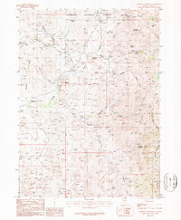
1986 Map of Cornwall Mountain
USGS Topo · Published 1987About this map
Humboldt National Forest encompasses the high country of Elko County in this mid-1980s provisional study, a landscape defined by sharp peaks and a legacy of mineral exploration. The terrain is anchored by Cornwall Mountain and Cornwall Pass, with Island Mountain and Little Island Mountain rising above the surrounding drainages. Mining activity is evident throughout the canyons, ranging from the St Elmo Mine and Mine Shaft in the northeast to numerous prospects and an Adit tucked within Coleman Canyon. Small-scale infrastructure like a remote Landing Strip near Gold Creek and the settlement of Penrod suggest the area's utility for ranching or prospecting. A complex web of water sources, including Rosebud Spring, Fuzzie Spring, and Sweet Spring, sustains the high-altitude environment, feeding major waterways such as Poorman Creek and Hay Meadow Creek.
Find a feature on this map
37 named features on this map. Tap any name to fly to it.
Don’t see what you’re looking for? This feature index may not catch every label — zoom into the map to look around manually.
Map Details
Editions of this 1986 Cornwall Mountain Map
This is the sole edition of this map. No revisions or reprints were ever made.
Other maps of this area

1935 · Charleston
USGS Topo · 1:48,000

1936 · Mountain City
USGS Topo · 1:62,500

1936 · Rowland
USGS Topo · 1:48,000

1940 · Rowland
USGS Topo · 1:62,500

1940 · Mountain City
USGS Topo · 1:62,500

1942 · Mt. Velma
USGS Topo · 1:62,500

1955 · Wells
USGS Topo · 1:250,000

1956 · Wild Horse
USGS Topo · 1:62,500

1958 · Wells
USGS Topo · 1:250,000

1961 · Wells
USGS Topo · 1:250,000