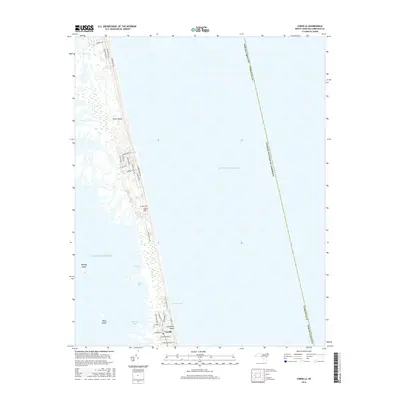
2016 Map of Corolla
USGS Topo · Published 2016About this map
Corolla occupies the narrowest stretch of the Outer Banks on this coastal survey, where the Atlantic shoreline and the waters of Currituck Beach define a fragile, linear geography. The map documents the residential and recreational development of the community, characterized by a dense network of local routes such as Corolla Village Rd and Schoolhouse Ln. To the west, the landscape transitions into the shallow, sheltered waters of the Currituck Sound, punctuated by Monkey Island and Mary Island. Landforms like Luark Hill stand as prominent markers along the dunes, while the interior sound side is shaped by a series of indentations including Jenkins Cove, Ships Bay, and Raccoon Bay. This survey captures the delicate balance between the exposed oceanfront and the protected marshy coves of Musketo Inlet, showing the area's modern infrastructure set against a dynamic barrier island ecosystem.
Find a feature on this map
34 named features on this map. Tap any name to fly to it.
Don’t see what you’re looking for? This feature index may not catch every label — zoom into the map to look around manually.
Map Details
Editions of this 2016 Corolla Map
This is the sole edition of this map. No revisions or reprints were ever made.
Other maps of this area

1893 · Virginia Beach
USGS Topo · 1:125,000

1916 · Back Bay
USGS Topo · 1:62,500

1940 · Barco
USGS Topo · 1:62,500

1943 · Back Bay
USGS Topo · 1:62,500

1946 · Eastville
USGS Topo · 1:250,000

1946 · Currituck Sound
USGS Topo · 1:250,000
1954 · Knotts Island
USGS Topo · 1:24,000

1961 · Eastville
USGS Topo · 1:250,000

1966 · Eastville
USGS Topo · 1:250,000
1982 · Barco
USGS Topo · 1:24,000