
1966 Map of Eastville
USGS Topo · Published 1966About this map
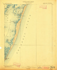
Chesapeake Bay and the Atlantic Ocean define this coastal landscape, which encompasses the narrow Delmarva Peninsula and the Outer Banks. The peninsula is dotted with agricultural and maritime settlements such as Eastville, Accomac, and Onancock, many connected by the rail corridor of the Norfolk & Southern. Along the Atlantic front, the complex barrier island system includes Assateague Island National Wildlife Refuge and Wallops Island, while the southern reaches show the early suburban footprint of Virginia Beach and military installations like Fort Story and Camp Pendleton. The map provides an intricate view of the shifting wetlands and inlets, from Chincoteague Inlet down to Currituck Sound. Navigational landmarks like the Janes Island Lighthouse and the Wright Monument at Kitty Hawk anchor the region's historical geography, reflecting a mix of lighthouse service, early aviation history, and coastal defense.
Find a feature on this map
113 named features on this map. Tap any name to fly to it.
Don’t see what you’re looking for? This feature index may not catch every label — zoom into the map to look around manually.
Map Details
Editions of this 1966 Eastville Map
This is the sole edition of this map. No revisions or reprints were ever made.
Other maps of this area

1893 · Virginia Beach
USGS Topo · 1:125,000

1898 · St. Marys
USGS Topo · 1:125,000

1901 · Snow Hill
USGS Topo · 1:62,500
1901 · Green Run
USGS Topo · 1:62,500

1903 · Crisfield
USGS Topo · 1:62,500

1903 · Bloodsworth Island
USGS Topo · 1:62,500

1903 · Deal Island
USGS Topo · 1:62,500

1906 · St. Marys
USGS Topo · 1:125,000

1907 · Norfolk
USGS Topo · 1:125,000

1916 · Back Bay
USGS Topo · 1:62,500