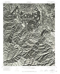
1974 Map of Corona South
USGS Topo · Published 1975About this map
Bedford Canyon defines the southern portion of this orthophotomap, showing the stark contrast between the complex drainage patterns of the Santa Ana Mountains and the expanding agricultural and suburban grid of Riverside and Orange counties in the mid-1970s. The aerial imagery captures a critical moment of transformation as large citrus groves and field crops still dominate the central valley floor, though residential developments are clearly beginning to encroach from the northern and western margins. These 1974 photographs, produced by the Orange County Board of Supervisors and the Geological Survey, provide an overhead perspective on the transition from an agrarian economy to a suburban landscape, tracing the precise alignment of local roads and irrigation patterns before further urbanization.
Find a feature on this map
1 named feature on this map. Tap any name to fly to it.
Don’t see what you’re looking for? This feature index may not catch every label — zoom into the map to look around manually.
Map Details
Editions of this 1974 Corona South Map
This is the sole edition of this map. No revisions or reprints were ever made.
Other maps of this area

1901 · Southern California Sheet No. 1
USGS Topo · 1:250,000

1901 · Elsinore
USGS Topo · 1:125,000

1901 · Riverside
USGS Topo · 1:62,500

1902 · Corona
USGS Topo · 1:125,000

1904 · Southern California Sheet No. 1
USGS Topo · 1:250,000
1933 · Prado
USGS Topo · 1:31,680

1935 · El Toro
USGS Topo · 1:31,680
1941 · Prado
USGS Topo · 1:31,680

1942 · Lake Elsinore
USGS Topo · 1:62,500
1942 · Corona and Vicinity
USGS Topo · 1:31,680