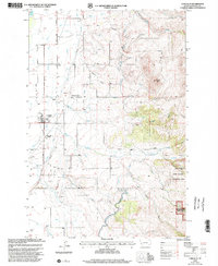
1998 Map of Corvallis
USGS Topo · Published 2002About this map
The Western Montana Experiment Station and the settlement of Corvallis anchor this late-twentieth-century landscape in the Bitterroot Valley. Agricultural irrigation is the defining human imprint here, visible through a complex network of man-made waterways including the Supply Canal, Hedge Ditch, and the Republican Ditch. These systems divert water to the valley floor from the rising eastern slopes where Bitterroot Nat For begins.
Find a feature on this map
31 named features on this map. Tap any name to fly to it.
Don’t see what you’re looking for? This feature index may not catch every label — zoom into the map to look around manually.
Map Details
Editions of this 1998 Corvallis Map
This is the sole edition of this map. No revisions or reprints were ever made.
Other maps of this area

1901 · Hamilton
USGS Topo · 1:125,000

1909 · Sapphire
USGS Topo · 1:125,000

1947 · Butte
USGS Topo · 1:250,000

1956 · Hamilton
USGS Topo · 1:250,000

1958 · Butte
USGS Topo · 1:250,000

1959 · Hamilton
USGS Topo · 1:250,000

1960 · Butte
USGS Topo · 1:250,000

1960 · Hamilton
USGS Topo · 1:250,000

1962 · Butte
USGS Topo · 1:250,000

1964 · Hamilton
USGS Topo · 1:250,000