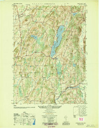
1951 Map of Cossayuna
USGS Topo · Published 1951About this map
Cossayuna Lake dominates this mid-century landscape of Washington County, its long basin flanked by the heights of Barkley Mtn and Murdock Mtn. The 1951 topographic survey reveals a rural society structured around small crossroad hamlets such as Argyle, South Argyle, and Cossayuna. Significant for local historians, the map identifies public institutions like the County Farm and rural educational centers including Rock Hill Sch and Beech Hill Sch. To the south, the Batten Kill flows through a broad valley near East Greenwich, while the eastern border is defined by Black Creek. The presence of several dedicated burial grounds, such as Argyle Cem and South Argyle Cem, provides essential location data for researchers tracing family ties to these upland townships. The terrain transitions from the rocky ridges of Browns Mtn to the low, wet expanses of The Old Fly and Peat Swamp.
Find a feature on this map
36 named features on this map. Tap any name to fly to it.
Don’t see what you’re looking for? This feature index may not catch every label — zoom into the map to look around manually.
Map Details
Editions of this 1951 Cossayuna Map
This is the sole edition of this map. No revisions or reprints were ever made.
Other maps of this area

1893 · Fort Ann
USGS Topo · 1:62,500

1895 · Cambridge
USGS Topo · 1:62,500

1895 · Fort Ann
USGS Topo · 1:62,500

1895 · Glens Falls
USGS Topo · 1:62,500

1897 · Glens Falls
USGS Topo · 1:62,500

1898 · Cambridge
USGS Topo · 1:62,500

1898 · Fort Ann
USGS Topo · 1:62,500

1900 · Schuylerville
USGS Topo · 1:62,500

1901 · Fort Ann
USGS Topo · 1:62,500

1901 · Cambridge
USGS Topo · 1:62,500