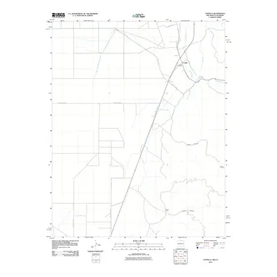
2010 Map of Costilla
USGS Topo · Published 2010About this map
Costilla sits near the northern New Mexico border, where a complex network of irrigation channels defines the high-desert agricultural landscape. The reliance on water management is evident through numerous named waterways like the Cordillera Ditch, Cerro Canal, and the Association Ditch, which divert Costilla Creek to sustain the local valley. This 2010 survey by the U.S. Geological Survey captures the community's infrastructure, including the Costilla Post Office and nearby Urraca Ranch. To the east, the terrain rises into the foothills, marked by deep incisions like Cedro Canyon and Jaroso Canyon. The presence of the Cedros Prospect suggests historical mineral exploration in the area, while the network of county roads, such as County Road B-051, connects these remote outposts. This map provides a detailed view of the traditional land-use patterns in Taos County, where the historic Acequia Madre continues to serve the region's acequia culture.
Find a feature on this map
19 named features on this map. Tap any name to fly to it.
Don’t see what you’re looking for? This feature index may not catch every label — zoom into the map to look around manually.
Map Details
Editions of this 2010 Costilla Map
This is the sole edition of this map. No revisions or reprints were ever made.
Other maps of this area

1954 · Raton
USGS Topo · 1:250,000

1954 · Trinidad
USGS Topo · 1:250,000

1955 · Trinidad
USGS Topo · 1:250,000

1958 · Raton
USGS Topo · 1:250,000

1958 · Trinidad
USGS Topo · 1:250,000

1959 · Trinidad
USGS Topo · 1:250,000

1963 · Costilla
USGS Topo · 1:24,000

1963 · Amalia
USGS Topo · 1:24,000

1963 · Cerro
USGS Topo · 1:24,000

1963 · Ute Mountain
USGS Topo · 1:24,000