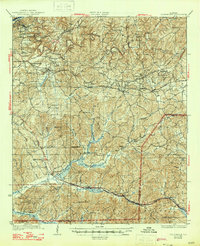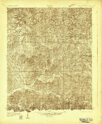
1931 Map of Cottondale
USGS Topo · Published 1931About this map
Cottondale and Coaling serve as central hubs in this early twentieth-century landscape, where industrial activity and rural community life overlap. The Black Warrior R clips the northwestern corner near Holt, while an extensive network of railroads including the Louisville and Nashville and Southern lines define the transport corridor. A significant glimpse into the regional timber industry is preserved through the Kaul Lumber Co (Abandoned) line, which once threaded through the southern forests toward Duncanville.
Find a feature on this map
70 named features on this map. Tap any name to fly to it.
Don’t see what you’re looking for? This feature index may not catch every label — zoom into the map to look around manually.
Map Details
Editions of this 1931 Cottondale Map
This is the sole edition of this map. No revisions or reprints were ever made.
Historical Maps of Tuscaloosa Through Time
8 maps found