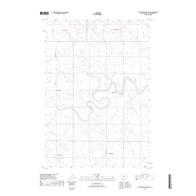
2017 Map of Cottonwood Creek NW
USGS Topo · Published 2017About this map
Grand River meanders deeply through the center of this Corson County landscape, creating a series of sharp oxbows and river bends that dominate the local topography. This 2017 survey captures the drainage patterns of the northern Great Plains, where numerous intermittent streams like Cedar Boy Cr and Meadow Cr feed into the primary river valley. The terrain is marked by the distinct drainage of Black Horse Butte Cr in the southwest, reflecting the erosional character of the Rock Creek District. Human presence is defined by the rigid section lines of the Public Land Survey System, which dictate the path of local routes such as Morristown Rd and 115th St. This map is particularly useful for visualizing how contemporary road networks and agricultural boundaries conform to the complex winding path of the Grand River.
Find a feature on this map
13 named features on this map. Tap any name to fly to it.
Don’t see what you’re looking for? This feature index may not catch every label — zoom into the map to look around manually.
Map Details
Editions of this 2017 Cottonwood Creek NW Map
This is the sole edition of this map. No revisions or reprints were ever made.
Other maps of this area

1953 · McIntosh
USGS Topo · 1:250,000

1956 · Cottonwood Creek NE
USGS Topo · 1:24,000

1956 · Cottonwood Creek SE
USGS Topo · 1:24,000

1956 · Cottonwood Creek NW
USGS Topo · 1:24,000

1956 · Cottonwood Creek SW
USGS Topo · 1:24,000

1958 · McIntosh
USGS Topo · 1:250,000

1972 · Morristown SE
USGS Topo · 1:24,000

1972 · Skull Butte
USGS Topo · 1:24,000

1972 · Thunder Hawk SE
USGS Topo · 1:24,000

1972 · Twin Butte
USGS Topo · 1:24,000