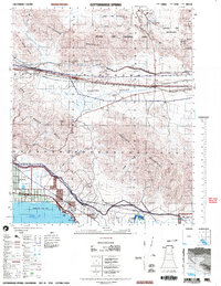
2003 Map of Cottonwood Spring
USGS Topo · Published 2004About this map
The Salton Sea shoreline dominates the southwestern corner of this survey, where the planned communities of North Shore, Mortmar, and Desert Beach meet the water. This arid landscape is a study in transitions, from the low-lying Torres Martinez Indian Reservation near the sea to the high desert terrain of Joshua Tree National Park in the north. The infrastructure of the Coachella Valley is clearly visible, with the Southern Pacific railroad and Highway 111 hugging the coast, while the 10 freeway cuts across Shavers Valley.
Find a feature on this map
28 named features on this map. Tap any name to fly to it.
Don’t see what you’re looking for? This feature index may not catch every label — zoom into the map to look around manually.
Map Details
Editions of this 2003 Cottonwood Spring Map
This is the sole edition of this map. No revisions or reprints were ever made.
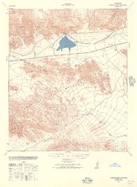
Other maps of this area

1904 · Indio
USGS Topo · 1:125,000

1931 · Vallecito
USGS Topo · 1:125,000

1940 · Frink
USGS Topo · 1:62,500

1940 · Cottonwood Spring
USGS Topo · 1:62,500
1940 · Canyon Spring
USGS Topo · 1:62,500

1940 · Durmid
USGS Topo · 1:62,500

1941 · Coachella
USGS Topo · 1:62,500

1942 · Agua Dulce
USGS Topo · 1:62,500

1943 · Vallecito
USGS Topo · 1:125,000

1943 · Canyon Spring
USGS Topo · 1:62,500