
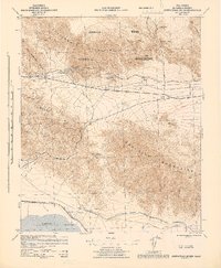
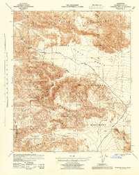
1943 Map of Canyon Spring
USGS Topo · Published 1944About this map
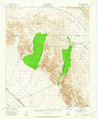
Joshua Tree National Monument occupies the northern reaches of this 1943 survey, where the Eagle Mountains dominate a landscape of high desert basins and sharp ridges. The central feature is the Hayfield Reservoir, a critical component of the regional water infrastructure supported by survey points like Hayfield East Base and Hayfield West Base. The map reveals a mid-century desert corridor defined by U.S. Route 60 and 70, which passes through the small settlement at Shaver Summit. To the south, the Orocopia Mountains and Chocolate Mountains hem in the drainage of Salton Creek. This area, mapped by the Corps of Engineers, U.S. Army during the war years, documents isolated desert resources like Canyon Spring, Clemens Well, and Tabaseco Tank, which were vital for travelers and ranchers in this arid environment.
Find a feature on this map
30 named features on this map. Tap any name to fly to it.
Don’t see what you’re looking for? This feature index may not catch every label — zoom into the map to look around manually.
Map Details
Editions of this 1943 Canyon Spring Map
This is the sole edition of this map. No revisions or reprints were ever made.
Other maps of this area

1940 · Frink
USGS Topo · 1:62,500

1940 · Cottonwood Spring
USGS Topo · 1:62,500
1940 · Iris Pass
USGS Topo · 1:62,500
1940 · Canyon Spring
USGS Topo · 1:62,500

1940 · Durmid
USGS Topo · 1:62,500
1943 · Coxcomb Mountains
USGS Topo · 1:62,500
1943 · Pinkham Well
USGS Topo · 1:62,500
1944 · Cottonwood Spring
USGS Topo · 1:62,500
1944 · Pinkham Well
USGS Topo · 1:62,500

1944 · Durmid
USGS Topo · 1:62,500