
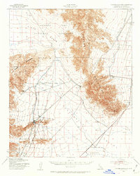
1943 Map of Coxcomb Mountains
USGS Topo · Published 1956About this map
Joshua Tree National Monument dominates the northwestern portion of this 1940s landscape, protecting the transition between the high desert and the Pinto Basin. This wartime survey, mapped by the Army Map Service, documents a sparsely populated but strategically important corridor in the Colorado Desert. The Colorado River Aqueduct is visible as it traverses the arid landscape, representing a massive feat of hydraulic engineering essential for Southern California's growth. To the southeast, the Chuckwalla Valley opens up, anchored by the CAA Intermediate Landing Field and the Parker Dam Highway, reflecting the region's role in mid-century aviation and transit. The survey provides topographic detail for the Coxcomb Mountains and Eagle Mountains, recording a wilderness before the era of intensive desert development.
Find a feature on this map
8 named features on this map. Tap any name to fly to it.
Don’t see what you’re looking for? This feature index may not catch every label — zoom into the map to look around manually.
Map Details
Editions of this 1943 Coxcomb Mountains Map
2 editions found
Other maps of this area

1940 · Canyon Spring
USGS Topo · 1:62,500

1942 · Amboy
USGS Topo · 1:250,000

1943 · Amboy
USGS Topo · 1:250,000

1943 · Cadiz Valley
USGS Topo · 1:62,500

1943 · Iron Mountains
USGS Topo · 1:62,500

1943 · Canyon Spring
USGS Topo · 1:62,500

1944 · Eagle Tank
USGS Topo · 1:62,500

1944 · Chuckwalla Mountains
USGS Topo · 1:62,500

1944 · Coxcomb Mountains
USGS Topo · 1:62,500

1952 · Sidewinder Well
USGS Topo · 1:62,500