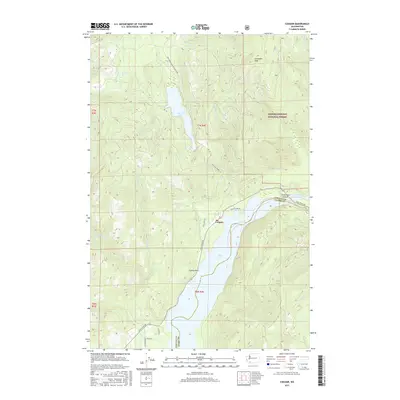
2017 Map of Cougar
USGS Topo · Published 2017About this map
Merrill Lake and the northern reaches of Yale Lake dominate this portion of the Cascade foothills, where the small community of Cougar serves as a gateway to the volcanic landscape. The map details the transition from the Gifford Pinchot National Forest to the waters of the Lewis River, tracing the river's path through engineered features like the Swift Number Two Forebay. High points like Cinnamon Peak overlook a complex network of forest development roads and local routes such as Old Lake Merrill Rd and Dog Creek Rd. The geography is defined by narrow canyons and rushing water, including Christmas Canyon and the Kalama Falls on the Kalama River. This survey captures the region's character as a hub for timber management and hydroelectric power, marked by the distinct boundary between Cowlitz and Clark Counties.
Find a feature on this map
30 named features on this map. Tap any name to fly to it.
Don’t see what you’re looking for? This feature index may not catch every label — zoom into the map to look around manually.
Map Details
Editions of this 2017 Cougar Map
This is the sole edition of this map. No revisions or reprints were ever made.
Other maps of this area

1919 · Mount St Helens
USGS Topo · 1:125,000

1940 · Lookout Mtn
USGS Topo · 1:62,500

1941 · Yacolt
USGS Topo · 1:62,500

1948 · Vancouver
USGS Topo · 1:250,000

1950 · Vancouver
USGS Topo · 1:250,000

1950 · Vancouver
USGS Topo · 1:250,000

1953 · Hoquiam
USGS Topo · 1:250,000

1953 · Lookout Mtn
USGS Topo · 1:62,500

1953 · Cougar
USGS Topo · 1:62,500
1956 · Yacolt
USGS Topo · 1:62,500