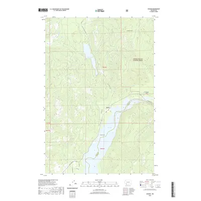
2020 Map of Cougar
USGS Topo · Published 2020About this map
Cougar sits at the junction of mountain waters and forest roads in this modern survey of the lower slopes of the Cascades. The settlement serves as a gateway to the Gifford Pinchot National Forest, positioned where the Lewis River Rd meets the northern reaches of Yale Lake. This landscape is defined by its dramatic hydrography, from the cascading Kalama Falls on the Kalama River to the high-elevation Merrill Lake, which is fed by Dry Cr and Fossil Cr. Local topography is marked by notable heights like Cinnamon Peak and the steep descent of Christmass Canyon. The map records a network of forest service arteries, including Natl Forest Develop Road 81 Rd and Old Lake Merrill Rd, which provide access to the timberlands and recreation sites along Speelyai Cr and Cougar Cr.
Find a feature on this map
32 named features on this map. Tap any name to fly to it.
Don’t see what you’re looking for? This feature index may not catch every label — zoom into the map to look around manually.
Map Details
Editions of this 2020 Cougar Map
This is the sole edition of this map. No revisions or reprints were ever made.
Other maps of this area

1919 · Mount St Helens
USGS Topo · 1:125,000

1940 · Lookout Mtn
USGS Topo · 1:62,500

1941 · Yacolt
USGS Topo · 1:62,500

1948 · Vancouver
USGS Topo · 1:250,000

1950 · Vancouver
USGS Topo · 1:250,000

1950 · Vancouver
USGS Topo · 1:250,000

1953 · Hoquiam
USGS Topo · 1:250,000

1953 · Lookout Mtn
USGS Topo · 1:62,500

1953 · Cougar
USGS Topo · 1:62,500
1956 · Yacolt
USGS Topo · 1:62,500