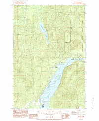
1983 Map of Cougar
USGS Topo · Published 1983About this map
Yale Lake and the Lewis River dominate this 1980s landscape, serving as the primary geographic corridor through the southern reaches of the Gifford Pinchot National Forest. The small settlement of Cougar sits at the northern tip of the lake, characterized by its local park system including Cougar Park and Cougar Camp, alongside a dedicated Trailer Park. This era reflects a transition toward managed recreation and conservation following the nearby volcanic activity, as evidenced by the inclusion of the Mount St Helens National Volcanic Monument along the eastern edge. To the north, Merrill Lake remains a focal point for outdoor activity with its Boat Ramp and Merrill Lake Campground. The presence of several Borrow Pits near the Kalama River suggests ongoing infrastructure maintenance in a region otherwise defined by high peaks like Cinnamon Peak and the cascade at Kalama Falls.
Find a feature on this map
31 named features on this map. Tap any name to fly to it.
Don’t see what you’re looking for? This feature index may not catch every label — zoom into the map to look around manually.
Map Details
Editions of this 1983 Cougar Map
This is the sole edition of this map. No revisions or reprints were ever made.
Other maps of this area

1919 · Mount St Helens
USGS Topo · 1:125,000

1940 · Lookout Mtn
USGS Topo · 1:62,500

1941 · Yacolt
USGS Topo · 1:62,500

1948 · Vancouver
USGS Topo · 1:250,000

1950 · Vancouver
USGS Topo · 1:250,000

1950 · Vancouver
USGS Topo · 1:250,000

1953 · Hoquiam
USGS Topo · 1:250,000

1953 · Lookout Mtn
USGS Topo · 1:62,500

1953 · Cougar
USGS Topo · 1:62,500
1956 · Yacolt
USGS Topo · 1:62,500