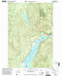
1998 Map of Cougar
USGS Topo · Published 2003About this map
Cougar sits at the northern end of Yale Lake, serving as a gateway to the volcanic landscapes of the Mount St Helens National Volcanic Monument. The late 20th-century landscape is defined by its recreation-oriented shoreline and industrial water management, featuring several designated campsites such as Beaver Bay Campground and Cougar Campground. This area of Cowlitz County shows a clear division between the protected wilderness of the Gifford Pinchot National Forest and the developed access points along the Lewis River.
Find a feature on this map
29 named features on this map. Tap any name to fly to it.
Don’t see what you’re looking for? This feature index may not catch every label — zoom into the map to look around manually.
Map Details
Editions of this 1998 Cougar Map
This is the sole edition of this map. No revisions or reprints were ever made.
Other maps of this area

1919 · Mount St Helens
USGS Topo · 1:125,000

1940 · Lookout Mtn
USGS Topo · 1:62,500

1941 · Yacolt
USGS Topo · 1:62,500

1948 · Vancouver
USGS Topo · 1:250,000

1950 · Vancouver
USGS Topo · 1:250,000

1950 · Vancouver
USGS Topo · 1:250,000

1953 · Hoquiam
USGS Topo · 1:250,000

1953 · Lookout Mtn
USGS Topo · 1:62,500

1953 · Cougar
USGS Topo · 1:62,500
1956 · Yacolt
USGS Topo · 1:62,500