
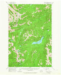
1988 Map of Cougar Lake
USGS Topo · Published 1998About this map
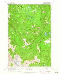
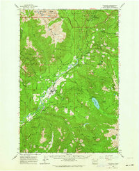
The Pacific Crest National Scenic Trail winds through this high-altitude landscape, crossing the triple-boundary junction of Pierce, Yakima, and Lewis Counties. This 1980s revision reveals a heavily protected wilderness where the Mount Rainier National Park meets the Snoqualmie National Forest and Gifford Pinchot National Forest. Evidence of early backcountry management is visible at the Patrol Cabin near Carlton, while the drainage of the American River and Bumping River structures the high basins. Dozens of alpine lakes define the terrain, from the large Cougar Lake and Dewey Lake to smaller features like Swamp Lake and Two Lakes. The topography is dominated by massive geological forms such as Crag Mountain and the Mesatchee Ridge, providing a look at the Cascades before modern digital mapping replaced these provisional field-checked surveys.
Find a feature on this map
44 named features on this map. Tap any name to fly to it.
Don’t see what you’re looking for? This feature index may not catch every label — zoom into the map to look around manually.
Map Details
Editions of this 1988 Cougar Lake Map
This is the sole edition of this map. No revisions or reprints were ever made.
Other maps of this area

1902 · Mount Aix
USGS Topo · 1:125,000

1904 · Mt Aix
USGS Topo · 1:125,000

1924 · Mt Rainier
USGS Topo · 1:96,000

1928 · Mt Rainier
USGS Topo · 1:125,000

1950 · Yakima
USGS Topo · 1:250,000

1958 · Yakima
USGS Topo · 1:250,000

1961 · Yakima
USGS Topo · 1:250,000
1962 · Bumping Lake
USGS Topo · 1:62,500
1962 · White Pass
USGS Topo · 1:62,500
1962 · Packwood
USGS Topo · 1:62,500