1962 Map of White Pass
USGS Topo · Published 1964About this map
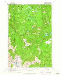
White Pass serves as the central focal point of this high-altitude landscape, where the boundary between Yakima and Lewis counties crosses the crest of the Cascades. The 1962 field-checked topography reveals a transition from the alpine reaches of Old Snowy Mtn and the McCall Glacier in the south to the reservoir system of Rimrock Lake and Clear Lake in the east. The map documents an era of established recreational and scientific use, featuring the State University Survey Camp and numerous sites like Soda Springs Campground and Falls Campground. Transport and movement are defined by a network of high-country routes including the Cascade Crest Trail and the Pinegrass Ridge Trail, while small-scale resource extraction is noted at a Prospect Indian and a standalone Mine near the Tieton River.
Find a feature on this map
128 named features on this map. Tap any name to fly to it.
Don’t see what you’re looking for? This feature index may not catch every label — zoom into the map to look around manually.
Map Details
Editions of this 1962 White Pass Map
2 editions found

Other maps of this area

1902 · Mount Aix
USGS Topo · 1:125,000

1904 · Mt Aix
USGS Topo · 1:125,000

1904 · Mount Adams
USGS Topo · 1:125,000

1907 · Mount Adams
USGS Topo · 1:125,000

1924 · Mt Rainier
USGS Topo · 1:96,000

1926 · Steamboat Mtn
USGS Topo · 1:125,000

1928 · Mt Rainier
USGS Topo · 1:125,000
1931 · Steamboat Mtn
USGS Topo · 1:125,000

1950 · Yakima
USGS Topo · 1:250,000

1958 · Yakima
USGS Topo · 1:250,000