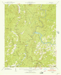
1941 Map of Cove Creek Gap
USGS Topo · Published 1956About this map
Great Smoky Mts Nat Park dominates the western half of this 1941 field examination, documenting a transition in the North Carolina mountains as rural homesteads gave way to protected lands. The presence of CCC Camp No 415 highlights the era of infrastructure development within the park, while small settlements like Ola, Nellie, and Cataloochee remain visible. Family lineages are preserved through numerous burial grounds such as Hannah Cem, Sutton Cem, and Teague Cem scattered across the ridges. The landscape is defined by the Pigeon River and the newly created Waterville Lake, controlled by the Waterville Dam. Social centers including the Beech Grove Sch, Little Cataloochee Ch, and Whiteoak Ch provide essential context for researchers tracing the pre-war communities of Haywood County.
Find a feature on this map
107 named features on this map. Tap any name to fly to it.
Don’t see what you’re looking for? This feature index may not catch every label — zoom into the map to look around manually.
Map Details
Editions of this 1941 Cove Creek Gap Map
This is the sole edition of this map. No revisions or reprints were ever made.
Other maps of this area

1893 · Mt Guyot
USGS Topo · 1:125,000

1894 · Asheville
USGS Topo · 1:125,000

1901 · Asheville
USGS Topo · 1:125,000

1912 · Mt Guyot
USGS Topo · 1:125,000

1935 · Newport
USGS Topo · 1:48,000
1935 · Hartford
USGS Topo · 1:24,000

1935 · Dellwood
USGS Topo · 1:24,000
1935 · Clyde
USGS Topo · 1:24,000

1935 · Lemon Gap
USGS Topo · 1:24,000

1936 · Bunches Bald
USGS Topo · 1:24,000