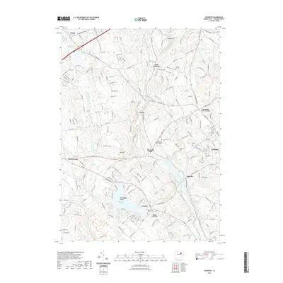
2021 Map of Coventry
USGS Topo · Published 2021About this map
Coventry Lake (Wangumbaug Lake) serves as a primary geographic anchor for this part of Tolland County, surrounded by the established villages of Coventry and South Coventry. The landscape is defined by the corridor of the Willimantic River and the Central Vermont RR, which connect various manufacturing and depot hamlets such as Mansfield Depot, Merrow, and Eagleville. The northeastern section includes the University of Connecticut Depot Campus and the edges of Storrs, illustrating the academic expansion that characterizes the modern era in this region.
Find a feature on this map
76 named features on this map. Tap any name to fly to it.
Don’t see what you’re looking for? This feature index may not catch every label — zoom into the map to look around manually.
Map Details
Editions of this 2021 Coventry Map
This is the sole edition of this map. No revisions or reprints were ever made.
Other maps of this area

1892 · Woodstock
USGS Topo · 1:62,500

1892 · Tolland
USGS Topo · 1:62,500

1892 · Norwich
USGS Topo · 1:62,500

1892 · Gilead
USGS Topo · 1:62,500

1921 · Tolland
USGS Topo · 1:62,500

1921 · Woodstock
USGS Topo · 1:62,500

1944 · Marlboro
USGS Topo · 1:31,680

1944 · South Coventry
USGS Topo · 1:31,680

1944 · Columbia
USGS Topo · 1:31,680
1944 · Rockville
USGS Topo · 1:31,680