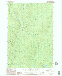
1989 Map of Cowen Hill
USGS Topo · Published 1989About this map
The remote borderlands of Pittsburg, New Hampshire, are defined by a complex network of timber camps and drainage systems near the international boundary with Canada. In this late twentieth-century landscape, seasonal activity is evidenced by Depot Camp, Cowen Hill Camp, and Klondyke Camp, which served as hubs for operations deep in the woods. The topography is dominated by the prominence of Covell Mtn and Cowen Hill, while the valley floor is carved by Indian Stream and its numerous tributaries. Notable water features such as Coon Brook Bog and Terrell Pond suggest the marshy, undisturbed character of the North Country terrain, providing a look at the logging infrastructure and geography of Coos County before significant modern changes.
Find a feature on this map
37 named features on this map. Tap any name to fly to it.
Don’t see what you’re looking for? This feature index may not catch every label — zoom into the map to look around manually.
Map Details
Editions of this 1989 Cowen Hill Map
This is the sole edition of this map. No revisions or reprints were ever made.
Other maps of this area

1925 · Indian Stream
USGS Topo · 1:48,000

1926 · Indian Stream
USGS Topo · 1:62,500

1927 · Indian Stream
USGS Topo · 1:62,500

1927 · Moose Bog
USGS Topo · 1:48,000

1927 · Second Lake
USGS Topo · 1:62,500

1931 · Moose Bog
USGS Topo · 1:62,500

1932 · Second Lake
USGS Topo · 1:62,500

1949 · Jackman
USGS Topo · 1:250,000

1963 · Jackman
USGS Topo · 1:250,000

1966 · Sherbrooke
USGS Topo · 1:250,000