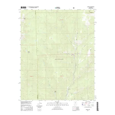
2017 Map of Cowles
USGS Topo · Published 2017About this map
Pecos River headwaters dominate this high-altitude landscape within the Santa Fe National Forest. The settlement of Cowles serves as a central point for a network of forest roads and trails, including Forest-121 Rd and State Rte 63, which follow the river's winding path south toward Holy Ghost. High peaks of the Sangre de Cristo Mountains, such as Redondo Peak, frame the western boundary where several alpine water bodies like Spirit Lake and Stewart Lake are found. The presence of the Pecos Mine Cem near the southern border provides a clear indicator of the area's industrial history, specifically its mining heritage. The map also captures the convergence of several drainages, including Winsor Cr and Punchuela Cr, which flow from the steep ridges of Grass Mtn and Round Mtn.
Find a feature on this map
37 named features on this map. Tap any name to fly to it.
Don’t see what you’re looking for? This feature index may not catch every label — zoom into the map to look around manually.
Map Details
Editions of this 2017 Cowles Map
This is the sole edition of this map. No revisions or reprints were ever made.
Other maps of this area

1889 · Santa Fe
USGS Topo · 1:125,000

1894 · Santa Fe
USGS Topo · 1:125,000

1953 · Sierra Mosca
USGS Topo · 1:24,000

1953 · Mc Clure Reservoir
USGS Topo · 1:24,000

1953 · Aspen Basin
USGS Topo · 1:24,000

1954 · Santa Fe
USGS Topo · 1:250,000

1958 · Santa Fe
USGS Topo · 1:250,000

1961 · Honey Boy Ranch
USGS Topo · 1:24,000

1961 · Rosilla Peak
USGS Topo · 1:24,000
1961 · Cowles
USGS Topo · 1:24,000