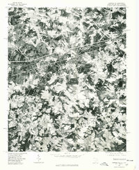
1975 Map of Cowpens NE
USGS Topo · Published 1979About this map
Broad River and the Second Broad River converge in this mid-1970s orthophoto, providing a clear visual record of the landscape at the South Carolina and North Carolina border. The imagery, rectified by the Geological Survey from 1975 aerial photography, reveals a patchwork of agricultural clearings and dense woodland corridors. The town of Chesnee sits in the southwestern quadrant, while the northern reaches show the industrial and residential footprints of Cliffside, Henrietta, and Harris. This specific photographic format is particularly valuable for genealogists and local historians, as it allows for the identification of unnamed homesteads, field boundaries, and rural road networks that standard topographic line maps often generalize. The concentration of settlements near the northern riverbanks suggests the historical influence of water power and river-based industry on the region's development.
Find a feature on this map
6 named features on this map. Tap any name to fly to it.
Don’t see what you’re looking for? This feature index may not catch every label — zoom into the map to look around manually.
Map Details
Editions of this 1975 Cowpens NE Map
This is the sole edition of this map. No revisions or reprints were ever made.
Other maps of this area

1909 · Gaffney
USGS Topo · 1:62,500

1950 · Shelby
USGS Topo · 1:62,500

1953 · Charlotte
USGS Topo · 1:250,000

1954 · Charlotte
USGS Topo · 1:250,000

1959 · Cowpens
USGS Topo · 1:62,500

1960 · Charlotte
USGS Topo · 1:250,000

1962 · Charlotte
USGS Topo · 1:250,000

1966 · Forest City
USGS Topo · 1:24,000
1966 · Rutherfordton South
USGS Topo · 1:24,000
1971 · Boiling Springs South
USGS Topo · 1:24,000