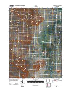
2011 Map of Coyote Buttes
USGS Topo · Published 2011About this map
Coyote Butte and Saddle Butte rise above the high desert floor of Harney County, defining a landscape shaped by water management and natural drainage. This 2011 survey details the complex hydrography of the Blitzen Valley, where the Donner und Blitzen River winds through the eastern portion of the quadrangle. The map reveals an intricate network of irrigation and water control features, including the Stubblefield Canal, Butte Ditch, and the meandering Simmons Slough. These man-made and natural watercourses intersect with local transit routes such as Center Patrol Rd and Rockford Ln, illustrating the historical and modern reliance on water diversion for ranching and land use in Coyote Flat. Near the southern boundary, Rattlesnake Butte stands as another prominent marker in this sparsely settled region of the Oregon interior.
Find a feature on this map
11 named features on this map. Tap any name to fly to it.
Don’t see what you’re looking for? This feature index may not catch every label — zoom into the map to look around manually.
Map Details
Editions of this 2011 Coyote Buttes Map
This is the sole edition of this map. No revisions or reprints were ever made.
Other maps of this area

1955 · Burns
USGS Topo · 1:250,000

1958 · Burns
USGS Topo · 1:250,000

1959 · Burns
USGS Topo · 1:250,000

1959 · Dog Mountain
USGS Topo · 1:62,500

1959 · Lawen
USGS Topo · 1:62,500

1967 · Coyote Buttes
USGS Topo · 1:24,000

1967 · Jackass Butte
USGS Topo · 1:24,000

1967 · Jackass Butte NE
USGS Topo · 1:24,000
1967 · Diamond Swamp
USGS Topo · 1:24,000

1978 · Malheur Lake
USGS Topo · 1:100,000