
1967 Map of Jackass Butte NE
USGS Topo · Published 1972About this map
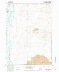
Diamond Craters and its associated Lava flows dominate the southeastern portion of this landscape, showcasing the volcanic geology of the High Desert. To the west, the Malheur National Wildlife Refuge provides a stark hydrological contrast, where the Donner und Blitzen River and the Blitzen River meander through a series of water management structures like Dunn Dam and Busse Dam. This 1967 survey illustrates the complex management of a desert wetland, featuring an extensive Canal system and the Patrol Road following the refuge boundary. High points such as Rattlesnake Butte overlook the basin, while the remote Stubblefield area and an isolated Landing Strip indicate the area's limited but essential infrastructure for conservation and range management.
Find a feature on this map
21 named features on this map. Tap any name to fly to it.
Don’t see what you’re looking for? This feature index may not catch every label — zoom into the map to look around manually.
Map Details
Editions of this 1967 Jackass Butte NE Map
2 editions found
Other maps of this area

1955 · Burns
USGS Topo · 1:250,000

1958 · Burns
USGS Topo · 1:250,000

1959 · Burns
USGS Topo · 1:250,000

1959 · Lawen
USGS Topo · 1:62,500

1960 · Crane
USGS Topo · 1:62,500

1967 · Coyote Buttes
USGS Topo · 1:24,000

1967 · Jackass Butte
USGS Topo · 1:24,000

1967 · Barton Lake
USGS Topo · 1:24,000
1967 · Diamond Swamp
USGS Topo · 1:24,000

1967 · Diamond
USGS Topo · 1:24,000