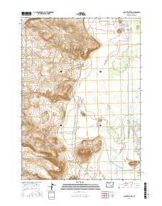
2017 Map of Coyote Buttes
USGS Topo · Published 2017About this map
The Donner und Blitzen River snakes through the eastern corridor of this landscape, defining the low-lying Blitzen Valley against a backdrop of high desert terrain. Water management is a central theme of the geography, evidenced by the presence of the Stubblefield Canal, Butte Ditch, and the seasonal Simmons Slough, which support the region's ranching and conservation efforts. To the west, the ground rises toward the expansive Coyote Flat and several prominent volcanic landmarks, including the namesake Coyote Buttes, Saddle Butte, and Rattlesnake Butte. Infrastructure is minimal, limited to utilitarian routes such as the Central Patrol Rd and Narrows-Princeton Rd, which provide access to this isolated portion of Harney County. The map provides a clear look at the Public Land Survey System grid, specifically within t27s r31e and surrounding townships, showing the intersection of natural drainage and human-engineered water systems.
Find a feature on this map
19 named features on this map. Tap any name to fly to it.
Don’t see what you’re looking for? This feature index may not catch every label — zoom into the map to look around manually.
Map Details
Editions of this 2017 Coyote Buttes Map
This is the sole edition of this map. No revisions or reprints were ever made.
Other maps of this area

1955 · Burns
USGS Topo · 1:250,000

1958 · Burns
USGS Topo · 1:250,000

1959 · Burns
USGS Topo · 1:250,000

1959 · Dog Mountain
USGS Topo · 1:62,500

1959 · Lawen
USGS Topo · 1:62,500

1967 · Coyote Buttes
USGS Topo · 1:24,000

1967 · Jackass Butte
USGS Topo · 1:24,000

1967 · Jackass Butte NE
USGS Topo · 1:24,000
1967 · Diamond Swamp
USGS Topo · 1:24,000

1978 · Malheur Lake
USGS Topo · 1:100,000