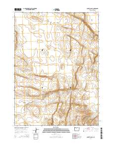
2014 Map of Coyote Gap SE
USGS Topo · Published 2014About this map
Catlow Valley and the surrounding high desert terrain define this corner of Harney County, offering a window into the wide-open landscape of southeastern Oregon as it appeared in 2014. The topography is marked by significant natural landforms like the Basque Hills and the rugged descent into Deadman Canyon. These features reflect the remote ranching and grazing heritage of the region, where named places often denote flat expanses like Butcher Flat amidst the complex elevation changes. The map meticulously records the township and range lines, such as t37s r31e, providing a precise spatial framework for land ownership and cattle country history. This 2014 survey captures the character of the Great Basin's northern reaches, where terrain names often carry the echoes of early settlers and the environmental realities of the high desert.
Find a feature on this map
9 named features on this map. Tap any name to fly to it.
Don’t see what you’re looking for? This feature index may not catch every label — zoom into the map to look around manually.
Map Details
Editions of this 2014 Coyote Gap SE Map
This is the sole edition of this map. No revisions or reprints were ever made.
Other maps of this area

1955 · Adel
USGS Topo · 1:250,000

1957 · Adel
USGS Topo · 1:250,000

1958 · Adel
USGS Topo · 1:250,000

1962 · Adel
USGS Topo · 1:250,000

1971 · Fish Fin Rim
USGS Topo · 1:24,000

1971 · Square Mountain
USGS Topo · 1:24,000
1971 · Acty Mountain NW
USGS Topo · 1:24,000

1971 · Surveyors Lake
USGS Topo · 1:24,000

1971 · Coyote Gap SE
USGS Topo · 1:24,000

1971 · Garrison Lake
USGS Topo · 1:24,000