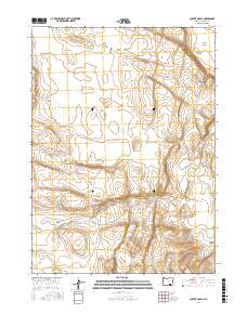
2017 Map of Coyote Gap SE
USGS Topo · Published 2017About this map
Catlow Valley defines the northern reaches of this high-desert landscape in Harney County, where the terrain transitions toward the elevations of the Basque Hills. This 2017 study by the U.S. Geological Survey details a remote area shaped by ranching history and public land management. Evidence of New Deal-era infrastructure is preserved in the form of the CCC Rd, which skirts the eastern edge of the quadrangle. To the south, Butcher Flat provides a wide, level expanse before the topography drops into the steep drainage of Deadman Canyon. The map reveals the intricate network of section lines and township boundaries that govern this expansive portion of the Oregon backcountry, reflecting the enduring legacy of the Public Land Survey System in the American West.
Find a feature on this map
10 named features on this map. Tap any name to fly to it.
Don’t see what you’re looking for? This feature index may not catch every label — zoom into the map to look around manually.
Map Details
Editions of this 2017 Coyote Gap SE Map
This is the sole edition of this map. No revisions or reprints were ever made.
Other maps of this area

1955 · Adel
USGS Topo · 1:250,000

1957 · Adel
USGS Topo · 1:250,000

1958 · Adel
USGS Topo · 1:250,000

1962 · Adel
USGS Topo · 1:250,000

1971 · Fish Fin Rim
USGS Topo · 1:24,000

1971 · Square Mountain
USGS Topo · 1:24,000
1971 · Acty Mountain NW
USGS Topo · 1:24,000

1971 · Surveyors Lake
USGS Topo · 1:24,000

1971 · Coyote Gap SE
USGS Topo · 1:24,000

1971 · Garrison Lake
USGS Topo · 1:24,000