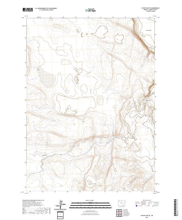
2023 Map of Coyote Gap SE
USGS Topo · Published 2023About this map
The high desert landscape of Catlow Valley dominates this 2023 survey of southeastern Harney County. The terrain transitions from the low-lying reaches of Butcher Flat toward the elevated Basque Hills in the south. This area is defined by its isolation and the clear evidence of public land management, with the notable presence of the CCC Rd cutting through the center of the quadrangle. This road reflects the region's history of landscape-scale infrastructure projects from the early 20th century that remain vital to the current transportation network. Further south, the topography deepens at Deadman Canyon, where the elevation contours tighten as they descend from the plateau toward the valley floor. The map provides a contemporary record of these geographic features, documenting the drainage patterns and relief that have shaped land use in this remote corner of Oregon.
Find a feature on this map
10 named features on this map. Tap any name to fly to it.
Don’t see what you’re looking for? This feature index may not catch every label — zoom into the map to look around manually.
Map Details
Editions of this 2023 Coyote Gap SE Map
This is the sole edition of this map. No revisions or reprints were ever made.
Other maps of this area

1955 · Adel
USGS Topo · 1:250,000

1957 · Adel
USGS Topo · 1:250,000

1958 · Adel
USGS Topo · 1:250,000

1962 · Adel
USGS Topo · 1:250,000

1971 · Fish Fin Rim
USGS Topo · 1:24,000

1971 · Square Mountain
USGS Topo · 1:24,000
1971 · Acty Mountain NW
USGS Topo · 1:24,000

1971 · Surveyors Lake
USGS Topo · 1:24,000

1971 · Coyote Gap SE
USGS Topo · 1:24,000

1971 · Garrison Lake
USGS Topo · 1:24,000