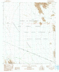
1990 Map of Coyote Water
USGS Topo · Published 1991About this map
The Camino Del Diablo winds across the southern reaches of this arid landscape, following the Wilderness Boundary through a region defined by isolation and military restricted space. As of the late twentieth century, this territory was managed as part of the Barry M Goldwater Air Force Range and the Cabeza Prieta Wilderness and National Wildlife Refuge, where human presence is strictly limited to designated paths. The topography is dominated by the Lechuguilla Desert floor, bisected by ephemeral drainages like Coyote Wash and La Jolla Wash. To the north and south, the horizon is anchored by the Cabeza Prieta Mountains and the Sierra de la Lechuguilla, while the presence of Coyote Water marks a critical, rare resource in this unforgiving environment.
Find a feature on this map
13 named features on this map. Tap any name to fly to it.
Don’t see what you’re looking for? This feature index may not catch every label — zoom into the map to look around manually.
Map Details
Editions of this 1990 Coyote Water Map
This is the sole edition of this map. No revisions or reprints were ever made.
Other maps of this area

1942 · Yuma
USGS Topo · 1:250,000

1953 · Ajo
USGS Topo · 1:250,000

1954 · El Centro
USGS Topo · 1:250,000

1955 · El Centro
USGS Topo · 1:250,000

1957 · Ajo
USGS Topo · 1:250,000

1958 · Ajo
USGS Topo · 1:250,000

1958 · El Centro
USGS Topo · 1:250,000

1961 · El Centro
USGS Topo · 1:250,000

1962 · Ajo
USGS Topo · 1:250,000

1963 · Ajo
USGS Topo · 1:250,000