
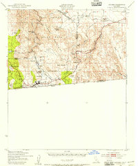
1943 Map of Coyote Wells
USGS Topo · Published 1945About this map
Coyote Wells serves as a central point in this arid landscape, situated along the Arizona Eastern rail line and the historic Old Stage Road. The map reveals a complex network of ephemeral drainage patterns, including Coyote Wash and its South Fork, which carve through the Yuha Basin. Scientific and historical interest is concentrated near the Shell Beds and Yuha Spring, while the presence of Vista de Anza suggests early scenic overlooks and recreational development in the Yuha Desert. Toward the south, the international boundary between the United States and Mexico is clearly delineated across the flat expanses of the basin. The eastern edge is defined by the West Side Canal, illustrating the vital irrigation infrastructure necessary for the region's agricultural edges.
Find a feature on this map
31 named features on this map. Tap any name to fly to it.
Don’t see what you’re looking for? This feature index may not catch every label — zoom into the map to look around manually.
Map Details
Editions of this 1943 Coyote Wells Map
This is the sole edition of this map. No revisions or reprints were ever made.
Other maps of this area

1915 · El Centro
USGS Topo · 1:125,000

1931 · Carrizo
USGS Topo · 1:125,000
1939 · Jacumba
USGS Topo · 1:62,500

1940 · Brawley
USGS Topo · 1:62,500
1940 · Heber
USGS Topo · 1:62,500

1940 · Plaster City
USGS Topo · 1:62,500

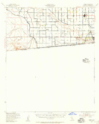
1940 · Coyote Wells
USGS Topo · 1:62,500

1942 · El Centro
USGS Topo · 1:250,000
1942 · Carrizo Mtn
USGS Topo · 1:62,500
1942 · Jacumba
USGS Topo · 1:62,500