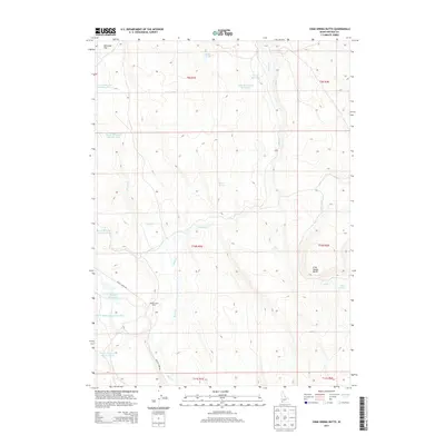
2013 Map of Crab Spring Butte
USGS Topo · Published 2013About this map
Battle Creek Ranch serves as a primary point of human activity in this high-desert landscape of southwestern Idaho. Located within Owyhee County, the terrain is defined by a sophisticated network of water management features, including Pole Cr Reservoir Number Five, Turner Reservoir, and Lahtinen Spring Reservoir. These man-made catchments, alongside natural features like Crab Spring and Rock Spring, reveal the critical importance of water rights and storage for ranching in this arid environment. The map shows the convergence of several major drainages, specifically Battle Cr, Rock Cr, and Little Jacks Cr, which carve through the high plateau. The area is accessed primarily via Battle Creek Rd, which winds past Antelope Flat and the prominent Crab Spring Butte in the southeastern corner, illustrating the remote and specialized agricultural infrastructure of the early 21st century.
Find a feature on this map
27 named features on this map. Tap any name to fly to it.
Don’t see what you’re looking for? This feature index may not catch every label — zoom into the map to look around manually.
Map Details
Editions of this 2013 Crab Spring Butte Map
This is the sole edition of this map. No revisions or reprints were ever made.
Other maps of this area

1955 · Jordan Valley
USGS Topo · 1:250,000

1957 · Jordan Valley
USGS Topo · 1:250,000

1958 · Jordan Valley
USGS Topo · 1:250,000
1972 · Frying Pan Basin
USGS Topo · 1:24,000
1972 · Big Springs Ranch
USGS Topo · 1:24,000
1972 · Crab Spring Butte
USGS Topo · 1:24,000

1972 · Turner Table
USGS Topo · 1:24,000
1972 · Snow Creek
USGS Topo · 1:24,000
1972 · O X Lake
USGS Topo · 1:24,000
1972 · Sugarloaf
USGS Topo · 1:24,000