
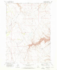
1972 Map of Turner Table
USGS Topo · Published 1976About this map
Turner Table dominates this high plateau region of Owyhee County, characterized by a complex network of springs and seasonal water management in the early 1970s. The landscape reflects a ranching economy dependent on features like the Monasterio-Jacks Creek Road Reservoir and the Turner Butte Dam. Small-scale operations are evident at the Morrow Ranch and Monasterio Ranch, while the presence of Whites House (Ruins) near Whites Reservoir points to an earlier layer of settlement that had already faded by the time of this survey. The terrain is deeply etched by Big Jacks Creek and Blue Creek, with numerous named water sources such as Angleworm Spring and Banks Spring supporting the livestock that utilized the Jacks Creek Meadows. A network of jeep trails provides the primary access across this remote corner of Idaho, linking the various reservoirs and ranch sites.
Find a feature on this map
20 named features on this map. Tap any name to fly to it.
Don’t see what you’re looking for? This feature index may not catch every label — zoom into the map to look around manually.
Map Details
Editions of this 1972 Turner Table Map
This is the sole edition of this map. No revisions or reprints were ever made.
Other maps of this area

1955 · Jordan Valley
USGS Topo · 1:250,000

1957 · Jordan Valley
USGS Topo · 1:250,000

1958 · Jordan Valley
USGS Topo · 1:250,000
1972 · Hill Pasture
USGS Topo · 1:24,000

1972 · Wickahoney Point
USGS Topo · 1:24,000

1972 · Little Blue Table
USGS Topo · 1:24,000
1972 · Crab Spring Butte
USGS Topo · 1:24,000
1972 · Nichol Flat
USGS Topo · 1:24,000
1972 · Shoofly Springs
USGS Topo · 1:24,000
1972 · Sugarloaf
USGS Topo · 1:24,000