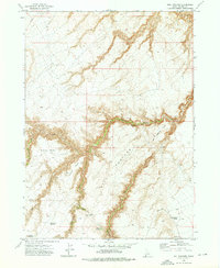
1972 Map of Hill Pasture
USGS Topo · Published 1975About this map
Hill Pasture in Owyhee County is defined by a complex network of high desert drainage systems and livestock-related landmarks as they appeared in the early 1970s. The landscape is carved by deep incisions such as Big Jacks Creek and Cottonwood Creek, which separate prominent landforms like Hill Pasture Point, Willies Point, and Harvey Point. Human presence in this arid region is marked by isolated outposts and water developments, including Holman Cabin and the Harvey Place. Connectivity across the plateaus and canyons is maintained via a network of Jeep Trails and a Pack Trail, emphasizing the area's use for ranching and resource management. Essential water sources for high-country operations are meticulously documented, from the Harveys V Reservoir to named flows like Jimmy Cappel Spring and Hicks Springs.
Find a feature on this map
23 named features on this map. Tap any name to fly to it.
Don’t see what you’re looking for? This feature index may not catch every label — zoom into the map to look around manually.
Map Details
Editions of this 1972 Hill Pasture Map
2 editions found
Other maps of this area

1955 · Jordan Valley
USGS Topo · 1:250,000

1955 · Twin Falls
USGS Topo · 1:250,000

1956 · Big Hill
USGS Topo · 1:62,500

1957 · Jordan Valley
USGS Topo · 1:250,000

1958 · Twin Falls
USGS Topo · 1:250,000

1958 · Jordan Valley
USGS Topo · 1:250,000

1972 · Wickahoney Point
USGS Topo · 1:24,000

1972 · Turner Table
USGS Topo · 1:24,000
1972 · Big Horse Basin Gap
USGS Topo · 1:24,000
1972 · O X Lake
USGS Topo · 1:24,000