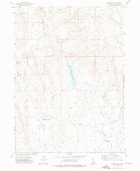
1972 Map of Nichol Flat
USGS Topo · Published 1976About this map
Portlock Ranch stands as the primary human landmark in this corner of Owyhee County during the early 1970s. The landscape is defined by the high, dry plateau of Nichol Flat, where a complex network of seasonal water management is visible through numerous impoundments such as Lower Nichol Flat Reservoir and Harris Creek Reservoir. This environment highlights the critical importance of water rights and ranching infrastructure in the high desert, as seen in the frequent Spring and Well markers scattered across the terrain.
Find a feature on this map
17 named features on this map. Tap any name to fly to it.
Don’t see what you’re looking for? This feature index may not catch every label — zoom into the map to look around manually.
Map Details
Editions of this 1972 Nichol Flat Map
This is the sole edition of this map. No revisions or reprints were ever made.
Other maps of this area

1955 · Jordan Valley
USGS Topo · 1:250,000

1957 · Jordan Valley
USGS Topo · 1:250,000

1958 · Jordan Valley
USGS Topo · 1:250,000
1971 · Flying H Ranch
USGS Topo · 1:24,000
1971 · Riddle
USGS Topo · 1:24,000

1971 · Ross Lake
USGS Topo · 1:24,000

1972 · Wickahoney Point
USGS Topo · 1:24,000

1972 · Little Blue Table
USGS Topo · 1:24,000

1972 · Turner Table
USGS Topo · 1:24,000
1972 · Shoofly Springs
USGS Topo · 1:24,000