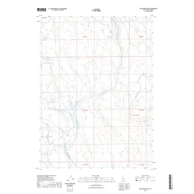
2023 Map of Crab Spring Butte
USGS Topo · Published 2023About this map
Antelope Flat and Crab Spring Butte define the high desert character of this Owyhee County landscape, where water management is central to the area's utility. The map shows a complex network of man-made water storage, including Turner Reservoir, Lahtinen Spring Reservoir, and multiple numbered basins along Dry Creek and Pole Creek Reservoir Number Three. This density of reservoirs suggests a land shaped by ranching and the necessity of capturing seasonal runoff in an arid environment. Transportation is limited to a few arterial routes like Battle Creek Rd, which provide access to remote springs such as Hutch Springs and Crab Spring. The inclusion of the indigenous place name Aivuhi Paatetiopai'i near Blue Creek adds a layer of cultural history to the standard topographic data.
Find a feature on this map
26 named features on this map. Tap any name to fly to it.
Don’t see what you’re looking for? This feature index may not catch every label — zoom into the map to look around manually.
Map Details
Editions of this 2023 Crab Spring Butte Map
This is the sole edition of this map. No revisions or reprints were ever made.
Other maps of this area

1955 · Jordan Valley
USGS Topo · 1:250,000

1957 · Jordan Valley
USGS Topo · 1:250,000

1958 · Jordan Valley
USGS Topo · 1:250,000
1972 · Frying Pan Basin
USGS Topo · 1:24,000
1972 · Big Springs Ranch
USGS Topo · 1:24,000
1972 · Crab Spring Butte
USGS Topo · 1:24,000

1972 · Turner Table
USGS Topo · 1:24,000
1972 · Snow Creek
USGS Topo · 1:24,000
1972 · O X Lake
USGS Topo · 1:24,000
1972 · Sugarloaf
USGS Topo · 1:24,000