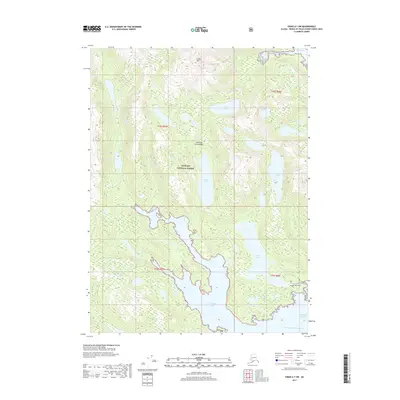
2017 Map of Craig A-1 SW
USGS Topo · Published 2017About this map
Alexander Archipelago coastal waters and dense timber dominate this 2017 survey of the Tongass National Forest in southeastern Alaska. The landscape is defined by the deep inlet of Dickman Bay and the sheltered West Arm Moira Sound which connect the interior mountain drainages to the Pacific Ocean. High elevations like Eudora Mtn look down upon a network of freshwater bodies including Aiken Lake, Kugel Lake, and Lake Luelia. The map identifies the Kegan Lake Trail near Kegan Lake, providing one of the few named land-based access points in this water-centric region. This area, largely free of permanent settlements, illustrates the characteristic interplay of tidal coves like Clarno Cove and glacial-fed creeks such as Aiken Cr and Kugel Cr.
Find a feature on this map
20 named features on this map. Tap any name to fly to it.
Don’t see what you’re looking for? This feature index may not catch every label — zoom into the map to look around manually.
Map Details
Editions of this 2017 Craig A-1 SW Map
This is the sole edition of this map. No revisions or reprints were ever made.
Other maps of this area

1948 · Dixon Entrance D-2
USGS Topo · 1:63,360

1948 · Craig A-1
USGS Topo · 1:63,360

1948 · Dixon Entrance D-1
USGS Topo · 1:63,360

1948 · Craig A-2
USGS Topo · 1:63,360

1951 · Dixon Entrance
USGS Topo · 1:250,000

1951 · Dixon Entrance D-2
USGS Topo · 1:63,360

1951 · Craig A-2
USGS Topo · 1:63,360

1957 · Craig
USGS Topo · 1:250,000

1959 · Dixon Entrance
USGS Topo · 1:250,000
1994 · Dixon Entrance D-1
USGS Topo · 1:63,360