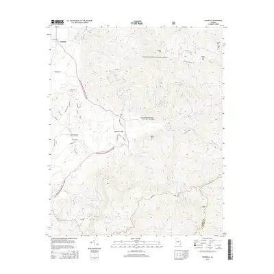
2014 Map of Crandall
USGS Topo · Published 2014About this map
Chattahoochee National Forest dominates this topographic landscape, where the high ridges of Grassy Mtn and Cohutta Mtn overlook the western valleys of Murray County. The small settlements of Crandall and Hasslers Mill are positioned at the forest's edge, serving as gateways to the steep terrain of the Blue Ridge. Local history is anchored by the Ernest Cem and the Charlie Kendrick Memorial Bridge, while the region's hydrography is defined by the winding course of Holly Creek and several small mountain lakes, including McDaniel Lake and Fort Mountain Lake. The map reveals a network of forest roads and creek-fed gaps, such as Emery Br and Milma Br, that once supported the timber and milling economies of the Georgia mountains.
Find a feature on this map
58 named features on this map. Tap any name to fly to it.
Don’t see what you’re looking for? This feature index may not catch every label — zoom into the map to look around manually.
Map Details
Editions of this 2014 Crandall Map
This is the sole edition of this map. No revisions or reprints were ever made.
Other maps of this area

1886 · Dalton
USGS Topo · 1:125,000

1892 · Dalton
USGS Topo · 1:125,000

1897 · Dalton
USGS Topo · 1:125,000

1911 · Cohutta Mtn
USGS Topo · 1:62,500

1913 · Cohutta Mtn.
USGS Topo · 1:62,500

1914 · Talking Rock
USGS Topo · 1:62,500

1916 · Talking Rock
USGS Topo · 1:62,500
1935 · Hemp Top
USGS Topo · 1:24,000

1938 · Chatsworth
USGS Topo · 1:48,000

1943 · Dalton
USGS Topo · 1:62,500