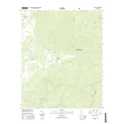
2017 Map of Crandall
USGS Topo · Published 2017About this map
Hasslers Mill serves as a central point in this mountainous region of the Chattahoochee National Forest. The landscape is dominated by significant peaks such as Fort Mtn, Grassy Mtn, and Cohutta Mtn, which define the drainage patterns for numerous waterways including Holly Cr and Emery Cr. For those researching local history, the Ernest Cem and the Charlie Kendrick Memorial Bridge provide specific points of geographic interest. The map illustrates a network of forest roads and trails like Old CCC Camp Rd and Cliffmine Rd, which connect remote areas to the community of Crandall. High-elevation water features, notably Conasauga Lake and Fort Mountain Lake, are prominent landmarks within the protected forest boundaries. The terrain's complexity is highlighted by the dense system of branches and prongs, such as Dry Prong and Goldmine Br, which feed into the larger creek systems of Murray County.
Find a feature on this map
59 named features on this map. Tap any name to fly to it.
Don’t see what you’re looking for? This feature index may not catch every label — zoom into the map to look around manually.
Map Details
Editions of this 2017 Crandall Map
This is the sole edition of this map. No revisions or reprints were ever made.
Other maps of this area

1886 · Dalton
USGS Topo · 1:125,000

1892 · Dalton
USGS Topo · 1:125,000

1897 · Dalton
USGS Topo · 1:125,000

1911 · Cohutta Mtn
USGS Topo · 1:62,500

1913 · Cohutta Mtn.
USGS Topo · 1:62,500

1914 · Talking Rock
USGS Topo · 1:62,500

1916 · Talking Rock
USGS Topo · 1:62,500
1935 · Hemp Top
USGS Topo · 1:24,000

1938 · Chatsworth
USGS Topo · 1:48,000

1943 · Dalton
USGS Topo · 1:62,500