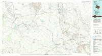
1986 Map of Crane
USGS Topo · Published 1994About this map
The Pecos River serves as a defining boundary in this West Texas landscape, winding between Ward, Crane, and Pecos counties. The mid-1980s terrain is heavily marked by the extensive infrastructure of the Permian Basin, where massive petroleum operations like the Mc Elroy Oil Field and Mc Camey Oil Field dominate the surface. Settlements such as Crane and Mc Camey serve as hubs for this energy-driven economy, while smaller locales like Grandfalls and Imperial are situated near the river's path.
Find a feature on this map
61 named features on this map. Tap any name to fly to it.
Don’t see what you’re looking for? This feature index may not catch every label — zoom into the map to look around manually.
Map Details
Editions of this 1986 Crane Map
3 editions found
Other maps of this area

1921 · Fort Stockton
USGS Topo · 1:62,500

1923 · Fort Stockton
USGS Topo · 1:62,500

1928 · Crane
USGS Topo · 1:125,000

1928 · Rankin
USGS Topo · 1:125,000

1928 · Comanche Spring
USGS Topo · 1:125,000

1929 · Sheffield
USGS Topo · 1:125,000

1929 · Hovey
USGS Topo · 1:125,000

1929 · Independence Draw Quadrangle
USGS Topo · 1:125,000

1931 · Barstow
USGS Topo · 1:125,000

1954 · Pecos
USGS Topo · 1:250,000