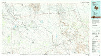
1986 Map of Crane
USGS Topo · Published 1994About this map
The Pecos River carves a winding path through this West Texas landscape, serving as a vital natural boundary for Crane, Ward Co, and Pecos Co. In the mid-1980s, the region's character was defined by an extensive network of petroleum infrastructure, with massive operations like the Mc Elroy Oil Field and Amacker-Tippett Oil Field spanning the arid plains. Small settlements such as Imperial, Grandfalls, and Royalty dot the river valley, while the Atchison Topeka and Santa Fe railroad cuts across the southern portion of the quadrangle near Girvin. The topography transitions from the shifting Sand Hills in the north to the prominent elevation of King Mountain and the Southwest Mesa in the southeast, illustrating the harsh but resource-rich environment of the Permian Basin at the height of its twentieth-century industrial development.
Find a feature on this map
58 named features on this map. Tap any name to fly to it.
Don’t see what you’re looking for? This feature index may not catch every label — zoom into the map to look around manually.
Map Details
Editions of this 1986 Crane Map
3 editions found
Other maps of this area

1921 · Fort Stockton
USGS Topo · 1:62,500

1923 · Fort Stockton
USGS Topo · 1:62,500

1928 · Crane
USGS Topo · 1:125,000

1928 · Rankin
USGS Topo · 1:125,000

1928 · Comanche Spring
USGS Topo · 1:125,000

1929 · Sheffield
USGS Topo · 1:125,000

1929 · Hovey
USGS Topo · 1:125,000

1929 · Independence Draw Quadrangle
USGS Topo · 1:125,000

1931 · Barstow
USGS Topo · 1:125,000

1954 · Pecos
USGS Topo · 1:250,000