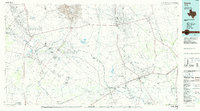
1986 Map of Crane
USGS Topo · Published 1986About this map
The Mc Elroy Oil Field and Sand Hills Oil Field dominate this mid-1980s landscape, reflecting the heavy industrial footprint of petroleum extraction across the Permian Basin. The Pecos River snakes through the western portion of the map, serving as a vital natural boundary between Ward and Pecos counties while supporting nearby settlements like Grandfalls and Royalty. This era shows a network of pipelines and service roads supporting the energy economy, contrasting with the expansive natural terrain of the Sand Hills and the prominent King Mountain range. Inland water features such as Juan Cordona Lake and Soda Lake appear as distinct landmarks in an otherwise arid environment. Along the southern edge, the Atchison Topeka and Santa Fe railroad tracks link the community of Mc Camey to the broader regional trade network, passing through significant terrain features like Boulder Flats.
Find a feature on this map
48 named features on this map. Tap any name to fly to it.
Don’t see what you’re looking for? This feature index may not catch every label — zoom into the map to look around manually.
Map Details
Editions of this 1986 Crane Map
3 editions found
Other maps of this area

1921 · Fort Stockton
USGS Topo · 1:62,500

1923 · Fort Stockton
USGS Topo · 1:62,500

1928 · Crane
USGS Topo · 1:125,000

1928 · Rankin
USGS Topo · 1:125,000

1928 · Comanche Spring
USGS Topo · 1:125,000

1929 · Sheffield
USGS Topo · 1:125,000

1929 · Hovey
USGS Topo · 1:125,000

1929 · Independence Draw Quadrangle
USGS Topo · 1:125,000

1931 · Barstow
USGS Topo · 1:125,000

1954 · Pecos
USGS Topo · 1:250,000