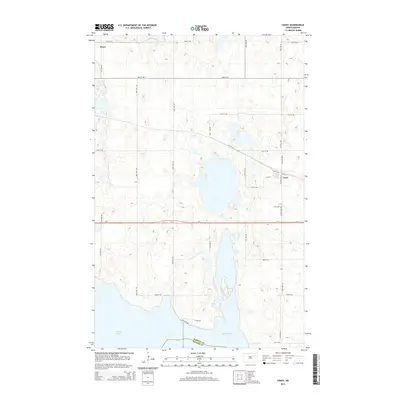
2014 Map of Crary
USGS Topo · Published 2014About this map
The town of Crary serves as the focal point of this North Dakota prairie landscape, situated just north of the massive shoreline of Devils Lake. This survey captures the intricate relationship between the region's expanding water levels and the established grid of section roads like 89th Ave NE and 46th St NE. The town is organized around a core street plan including Main St and Lyle St, while the Crary Cem sits slightly to the south along Co Road 3627. To the west, the locality of Essex marks a secondary point of settlement in this agricultural expanse. A significant portion of the southern map is dominated by East Devils Lake, showing how the rising waters have integrated with the local road network, such as E Lake Rd, and redefined the boundary between Ramsey Co and Benson Co.
Find a feature on this map
31 named features on this map. Tap any name to fly to it.
Don’t see what you’re looking for? This feature index may not catch every label — zoom into the map to look around manually.
Map Details
Editions of this 2014 Crary Map
This is the sole edition of this map. No revisions or reprints were ever made.
Other maps of this area

1928 · Tokio
USGS Topo · 1:62,500

1930 · Hamar
USGS Topo · 1:62,500

1931 · Tokio
USGS Topo · 1:62,500

1931 · Devils Lake
USGS Topo · 1:62,500

1950 · Tokio
USGS Topo · 1:24,000

1950 · Devils Lake
USGS Topo · 1:62,500

1950 · Devils Lake Mountain
USGS Topo · 1:24,000

1951 · Crary
USGS Topo · 1:24,000

1951 · Devils Lake Mountain
USGS Topo · 1:24,000

1951 · Devils Lake
USGS Topo · 1:24,000