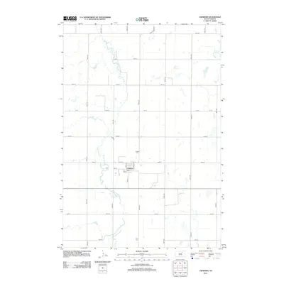
2012 Map of Cresbard
USGS Topo · Published 2012About this map
Cresbard serves as the primary focal point of this Faulk County prairie landscape, organized around a traditional grid of streets including Main St, Swift Ave, and Whitton Ave. A local Post Office marks the center of town life, while the surrounding agricultural lands are defined by a strict section-line road system. The meandering N Fork Snake Cr cuts through the western half of the map, contrasting with the geometric precision of the fields. Two significant sites for local history and genealogy are present: Cresbard Cem north of the settlement and Hope Cem located further south near 156th St. In the northeastern corner, Tomek Slough provides a natural break in the farmland, illustrating the persistent prairie potholes that characterize this region of South Dakota.
Find a feature on this map
31 named features on this map. Tap any name to fly to it.
Don’t see what you’re looking for? This feature index may not catch every label — zoom into the map to look around manually.
Map Details
Editions of this 2012 Cresbard Map
This is the sole edition of this map. No revisions or reprints were ever made.
Other maps of this area

1899 · Northville
USGS Topo · 1:125,000

1952 · Wecota
USGS Topo · 1:24,000

1952 · Faulkton East
USGS Topo · 1:24,000

1954 · Aberdeen
USGS Topo · 1:250,000

1956 · Aberdeen
USGS Topo · 1:250,000

1966 · Cresbard SE
USGS Topo · 1:24,000
1966 · Cresbard SW
USGS Topo · 1:24,000
1966 · Cresbard NE
USGS Topo · 1:24,000

1966 · Cresbard
USGS Topo · 1:24,000

1970 · Mina SW
USGS Topo · 1:24,000