
1899 Map of Northville
USGS Topo · Published 1899About this map
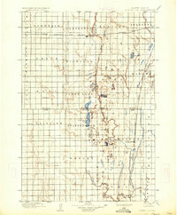
Northville and its surrounding prairie townships define this 1890s landscape at the crossroads of Spink, Brown, Faulk, and Edmunds counties. The region's development is anchored by the crossing of the Chicago and Northwestern RR and the Chicago Milwaukee and St. Paul RR, which connected agricultural hubs like Cortlandt and Athol to the wider grain markets. The terrain is marked by intermittent water bodies such as Salt Lake and Lords Lake, alongside the prominent Scatterwood Lake. Small settlements like Cresbard, Devoe, and St. Herbert are distributed across the township grid, illustrating the early settlement patterns of the South Dakota plains. The survey, conducted by D.C. Harrison and H.S. Wallace, meticulously captures the winding course of Snake Creek as it moves through the central and southern portions of the quadrangle.
Find a feature on this map
41 named features on this map. Tap any name to fly to it.
Don’t see what you’re looking for? This feature index may not catch every label — zoom into the map to look around manually.
Map Details
Editions of this 1899 Northville Map
2 editions found
Other maps of this area

1894 · Columbia
USGS Topo · 1:62,500

1895 · Byron
USGS Topo · 1:125,000

1895 · Aberdeen
USGS Topo · 1:125,000

1896 · Columbia
USGS Topo · 1:125,000

1899 · Ellendale
USGS Topo · 1:125,000

1899 · Redfield
USGS Topo · 1:125,000
1951 · Orient
USGS Topo · 1:24,000
1952 · Wecota
USGS Topo · 1:24,000
1952 · Faulkton East
USGS Topo · 1:24,000

1952 · Ordway
USGS Topo · 1:24,000
Featured Places
- Aberdeen, Aberdeen Township
- Warner, Warner Township
- Mellette, Mellette Township
- Cresbard, SD
- Northville, Northville Township