
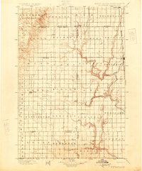
1899 Map of Ellendale
USGS Topo · Published 1899About this map
The Chicago Milwaukee and St. Paul R. R. (James River Div.) anchors the eastern edge of this late nineteenth-century landscape, connecting the growing hub of Ellendale with the settlement of Frederick. This period of prairie development is characterized by a precise grid of township and section lines that overlay the natural winding paths of the Elm River and Willow Creek. While the eastern portion of the survey reflects the burgeoning rail economy, the western sections towards Leola and Sutherland show a more dispersed rural character, dotted with early stops and post offices like Alpha and Delhi. Subtle relief shading reveals the elevation changes between the James River valley and the higher plains to the west, tracing the path of seasonal waterways including Foot Creek and Snake Creek across several county boundaries.
Find a feature on this map
48 named features on this map. Tap any name to fly to it.
Don’t see what you’re looking for? This feature index may not catch every label — zoom into the map to look around manually.
Map Details
Editions of this 1899 Ellendale Map
2 editions found
Other maps of this area

1894 · Monango
USGS Topo · 1:62,500

1894 · Ellendale
USGS Topo · 1:62,500

1894 · Columbia
USGS Topo · 1:62,500

1894 · Savo
USGS Topo · 1:62,500

1894 · Fullerton
USGS Topo · 1:62,500

1895 · Lamoure
USGS Topo · 1:125,000

1895 · Aberdeen
USGS Topo · 1:125,000

1896 · Columbia
USGS Topo · 1:125,000

1896 · Edgeley
USGS Topo · 1:125,000

1899 · Northville
USGS Topo · 1:125,000