
1894 Map of Ellendale
USGS Topo · Published 1894About this map
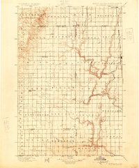
Ellendale serves as the primary northern anchor of this late nineteenth-century survey, situated at the edge of Dickey County near the North Dakota and South Dakota border. The landscape is defined by the winding course of the Elm River and the Maple River to the south, which cut through the prairie townships of Wheatland, Palmyra, and Osceola. This period of settlement is marked by the presence of the Chicago Milwaukee and St. Paul Railway, which runs north-south through Frederick, providing a vital corridor for the agricultural townships. The survey, conducted by D.C. Harrison under the direction of J.W. Powell, illustrates the early grid system and the proximity of these frontier communities to the established state boundary lines.
Find a feature on this map
16 named features on this map. Tap any name to fly to it.
Don’t see what you’re looking for? This feature index may not catch every label — zoom into the map to look around manually.
Map Details
Editions of this 1894 Ellendale Map
This is the sole edition of this map. No revisions or reprints were ever made.
Historical Maps of Ellendale Through Time
Featured Locations
- Franklyn Township, SD
- Ellendale, ND
- Elm Township, ND
- Van Meter Township, ND
- Frederick, Frederick Township