
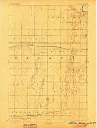
1894 Map of Fullerton
USGS Topo · Published 1894About this map
Fullerton and the surrounding townships of Dickey County appear here in the early 1890s, organized into a strict grid of sections and civil boundaries. The landscape is defined by the winding course of the Maple River, which meanders south through Kentner and Van Meter. Transportation and commerce are anchored by two major rail lines: the Minneapolis St. Paul and Sault Ste. Marie R.R. passing through Fullerton and Yorktown, and the St. Paul Minneapolis and Manitoba R.R. running across the southern portion of the sheet near Silver Leaf. This survey illustrates the early settlement patterns of the Dakota prairie, where township names like Wright, Porter, and Ada demarcated the land for incoming pioneers and agricultural development.
Find a feature on this map
14 named features on this map. Tap any name to fly to it.
Don’t see what you’re looking for? This feature index may not catch every label — zoom into the map to look around manually.
Map Details
Editions of this 1894 Fullerton Map
2 editions found
Other maps of this area

1894 · Monango
USGS Topo · 1:62,500

1894 · La Moure
USGS Topo · 1:62,500

1894 · Ellendale
USGS Topo · 1:62,500

1894 · Hecla
USGS Topo · 1:62,500

1894 · Savo
USGS Topo · 1:62,500

1894 · Oakes
USGS Topo · 1:62,500

1895 · Lamoure
USGS Topo · 1:125,000

1896 · Columbia
USGS Topo · 1:125,000

1896 · Edgeley
USGS Topo · 1:125,000

1899 · Ellendale
USGS Topo · 1:125,000