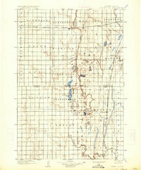
1899 Map of Northville
USGS Topo · Published 1934About this map
Northville stands at the intersection of the prairie landscape and industrial expansion in this late 19th-century survey of Spink, Brown, Edmunds, and Faulk counties. The region is defined by the early development of the Chicago and Northwestern R. R. and the Chicago Milwaukee and St. Paul R. R., which facilitated the growth of small rail stops like Cortlandt, Athol, and Rudolph. The hydrology of the area is particularly detailed, featuring numerous small bodies of water such as Scatterwood Lake, Lords Lake, and Salt Lake, which punctuate the drainage basins of Snake Creek and its branches.
Find a feature on this map
41 named features on this map. Tap any name to fly to it.
Don’t see what you’re looking for? This feature index may not catch every label — zoom into the map to look around manually.
Map Details
Editions of this 1899 Northville Map
2 editions found
Other maps of this area

1894 · Columbia
USGS Topo · 1:62,500

1895 · Byron
USGS Topo · 1:125,000

1895 · Aberdeen
USGS Topo · 1:125,000

1896 · Columbia
USGS Topo · 1:125,000

1899 · Ellendale
USGS Topo · 1:125,000

1899 · Northville
USGS Topo · 1:125,000

1899 · Redfield
USGS Topo · 1:125,000
1951 · Orient
USGS Topo · 1:24,000
1952 · Wecota
USGS Topo · 1:24,000
1952 · Faulkton East
USGS Topo · 1:24,000
Featured Places
- Aberdeen, Aberdeen Township
- Warner, Warner Township
- Mellette, Mellette Township
- Cresbard, SD
- Northville, Northville Township