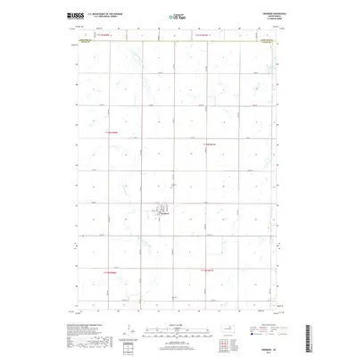
2017 Map of Cresbard
USGS Topo · Published 2017About this map
Cresbard serves as the central hub of this prairie landscape near the border of Edmunds and Faulk counties. The town's grid is clearly defined by several residential and commercial corridors, including Main St, Swift Ave, and Howard Ave, reflecting the organized growth of a small South Dakota agricultural center. The surrounding rural sections are defined by a high density of wetlands and depressions typical of the Missouri Coteau region, notably Tomek Slough and the winding course of the North Fork Snake Creek. Genealogy researchers will find precise locations for the Cresbard Cem north of town and Hope Cem to the south, while the network of section-line roads like Co Rd 15 illustrates the enduring geometry of the Great Plains land system.
Find a feature on this map
39 named features on this map. Tap any name to fly to it.
Don’t see what you’re looking for? This feature index may not catch every label — zoom into the map to look around manually.
Map Details
Editions of this 2017 Cresbard Map
This is the sole edition of this map. No revisions or reprints were ever made.
Other maps of this area

1899 · Northville
USGS Topo · 1:125,000

1952 · Wecota
USGS Topo · 1:24,000

1952 · Faulkton East
USGS Topo · 1:24,000

1954 · Aberdeen
USGS Topo · 1:250,000

1956 · Aberdeen
USGS Topo · 1:250,000

1966 · Cresbard SE
USGS Topo · 1:24,000
1966 · Cresbard SW
USGS Topo · 1:24,000
1966 · Cresbard NE
USGS Topo · 1:24,000

1966 · Cresbard
USGS Topo · 1:24,000

1970 · Mina SW
USGS Topo · 1:24,000